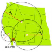
Identify the location of an earthquake epicenter using a travel time graph and three seismograph tracings. The epicenter is the point on Earth's surface directly above an earthquake. Seismic stations detect earthquakes by the tracings made on seismographs. Tracings made at three separate seismic stations are needed to locate an earthquake epicenter.
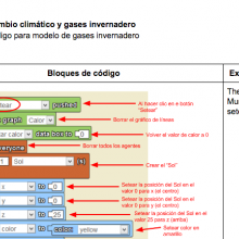
Es una hoja de referencia con los bloques de código necesarios para el modelo de cambio climático. Se explica bloque por bloque qué función cumple cada estructura en cada pestaña de la programación con StarLogo NOVA.
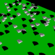
A model demonstrating the albedo effect of black or white surfaces. Use as a part of the Climate Change and Agriculture Project GUTS Curricular Unit, or as a stand-alone model, activity, and video.